Valitse organisaatio
Data Flow in Salesforce Maps Territory Planning
Julkaisupäivä: Aug 25, 2026
Kuvaus
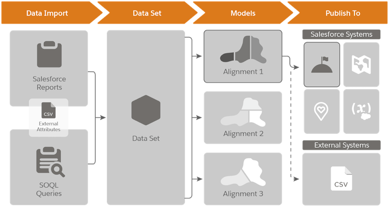
Salesforce Maps Territory Planning follows a simplified data flow: define your Salesforce Report or SOQL query criteria, create a data set, create alignments, and publish. This article explains each stage of that data flow.
Ratkaisu
This article explains how data flows through Salesforce Maps Territory Planning, from importing Salesforce data through publishing your finished territory plan.
Import Data
To import data into the application, you can use a single or multiple Salesforce reports, a SOQL query, or a combination of both. The data pulled from these sources is then imported as a data set into Territory Planning.
Note: The Salesforce report or SOQL query being used to import data should contain the Salesforce Object Id, Latitude, and Longitude values at a minimum.
Create a Data Set
A data set is a copy of the data specified or intended to pull from the source report or query used. This copy is a point-in-time calculation and doesn't link back to the original report or SOQL query. Because of this, any changes made to the data set in the Territory Planning application will not change your Salesforce data, or vice versa. This lets you plan against static data during your territory carving activity. You can use the Clone and Refresh feature to create a copy of your data set and re-run the reports or queries to return the latest data in a new data set.
Once the Salesforce object data is imported into the data set, it is referred to as a unit in Territory Planning. A unit can be any Salesforce Object with a Latitude and Longitude value.
Create an Alignment
Once the data set is created, you can then create an alignment. An alignment is a map-based visualization tool used for planning different scenarios and adjusting the assignment values of your unit data without impacting the Salesforce data. Data sets can have multiple alignments, which represent different planning scenarios. You can use alignments for planning and invite other users to provide feedback before committing alignment changes back to Salesforce. Alignments must be published before they can update any Salesforce data.
Note: You can also enrich your data with external attribute data (CSV file). External attributes can only enrich existing Salesforce records and cannot add new records. Although this can be done either during data set creation or while working in an existing alignment, it's best practice to import external attributes when creating the data set — this ensures the data carries over to all alignments associated with the data set.
Publish Data
Once your planning activities are complete, you can publish assignment changes using five publishing options: Enterprise Territory Management (ETM), Salesforce Maps Shape Layers and Auto Assignment Rules, Salesforce Fields, PDF handout, and/or CSV.
- Salesforce Maps: Territories publish as shape layers, which can be linked to auto assignment rules in Salesforce Maps Settings. These rules can be generated automatically from Territory Planning, associate the shape layer with the Territory Owner, and can point to specific Salesforce objects to update user lookup values such as OwnerId.
- Enterprise Territory Management (ETM): You can publish territories, users, manually assigned accounts, and geographic assignment rules. Your territory owner and any additional users are assigned to the corresponding territory. You can create geographic assignment rules based on the Territory Boundary selected during data set creation, such as United States Postal Codes. Locked units can also be published as manually assigned accounts.
- Field Service (FSL): You can publish your alignment directly to the Field Service managed package as Service Territories and Service Territory Polygons. This option only appears for orgs that have Field Service enabled and the managed package installed, and only publishes Service Territories and Service Territory Polygons.
- Salesforce Fields: You can write Territory Planning object and field values directly to fields on Salesforce records such as Accounts, Opportunities, Leads, and even custom objects — this lets you operationalize your territory designs without needing an intermediary tool like ETM or Salesforce Maps.
- CSV: You can quickly create extracts of the entire focus or alignment without needing to select anything on the map. You can also use Export to CSV to extract selected information at any level of your legend, useful for updating external systems.
Note: Publish to CSV was introduced in Winter '22.
Lisäresurssit
Knowledge-artikkelin numero
000389035
Ratkaisiko tämä artikkeli ongelmasi?
Anna palautetta, jotta voimme kehittyä!