
Set Up a Native GIS Connector
To view Salesforce objects on the map, define a connector to automatically sync the Salesforce data with the relevant ArcGIS hosted feature layer. Map Salesforce objects and fields with ArcGIS layers, and define how often the connector should run. To update data at different intervals, you can create multiple connectors for each type of sync interval.
Required Editions
| Available in: Lightning Experience. |
| Available in: Enterprise Edition with the Asset Service Lifecycle Management add-on license, or in Performance, Unlimited, and Developer Editions. |
| User Permissions Needed | |
|---|---|
| To set up connectors: | Customize Application |

Note The connector creates and updates the records modified since the last sync, based
on the Last Modified field on the record. During its initial run, the connector processes all
changes from the previous seven days.
- From Setup, find and select Field Maps Settings and then select Connector.
- Click New Connector.
- Enter a name and select the authentication record that you created.
- Click Next.
-
Click the
 icon and select an object that you want to sync. For example, Work Order, Work Order
Line Item, Account, Location, Asset, or any custom objects that you’ve defined.
icon and select an object that you want to sync. For example, Work Order, Work Order
Line Item, Account, Location, Asset, or any custom objects that you’ve defined.
-
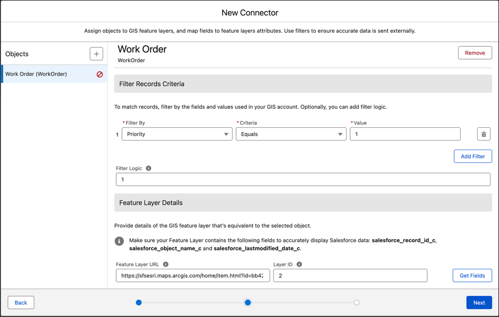
You can define filters to update data for records containing specific values.
- From Filter By, select the field to use to update ArcGIS.
- Define the criteria and a value.
- Define more fields as required.
- Add filter logic to define how and when to apply the filters, using AND and OR logic.
-
Under Feature Layer Details, define the details of the ArcGIS
feature layer and the specific layer you want to connect to.
- For Feature Layer URL, navigate to the feature layer in your ArcGIS account and copy the URL.
-
For Layer ID, enter 0 if your feature layer has only 1 layer. If
it has multiple layers, open the layer and extract the value that appears after the sublayer
query param in the browser’s URL. For example, if the layer’s browser URL is:
https://sfsesri.maps.arcgis.com/home/item.html?id=bb42fdb05a46406c8082b9cb0a4ca526&sublayer=2,the Layer ID is 2.
- Click Get Fields and make sure that you see Assign Object Fields to Feature Layer Fields and Assign Geometry Fields. If you receive an error, make sure that you’ve set up the authentication record correctly.
-
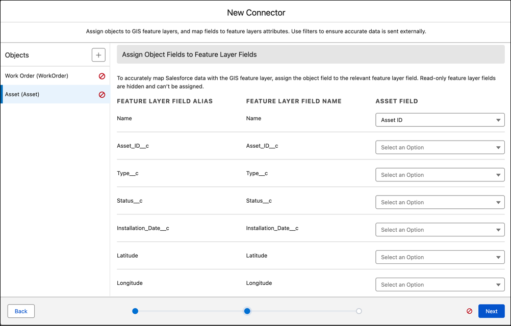
Under Assign Object Fields to Feature Layer Fields, you can map an object field to the
equivalent field in the layer’s table in ArcGIS.
-
Assign the Geometry types to an object field, which must contain a value.
- For polygons and lines, choose a text field, which includes a GeoJSON format.
- For points, choose a field of geolocation type.
- Click Next.
- Set the connector’s status to Active.
- Under Send connector data, define how often to sync Salesforce data with ArcGIS.
- Save your changes.
Considerations
- You can configure up to three connectors and push up to 150 million records from Salesforce to ArcGIS within a 24-hour period. You can push up to 10K records in a single update.
- To avoid data conflicts, don’t send the same records to multiple feature layers.
- The Native GIS Connector treats Salesforce as the source of truth and syncs one way. The connector doesn’t detect changes that you make directly in ArcGIS. If you update a record in both Salesforce and ArcGIS, the next connector run overwrites the ArcGIS changes with the Salesforce values. If you delete a record in ArcGIS but the record still exists in Salesforce, the next connector run doesn’t push the record again, because the connector resyncs only records whose Last Modified date in Salesforce has changed.
- To restore a record that you deleted in ArcGIS but that still exists in Salesforce, edit the Salesforce record so its Last Modified date is updated, and then wait for the next connector run.
- To prevent duplicate records in ArcGIS, set the Salesforce record ID field as unique in the ArcGIS feature layer. The connector uses the Salesforce record ID to match records on update.
- The connector retains historical data for a maximum of 30 days.
- If you’re not using a connector, spatial records don’t appear on the map in real time.
- The Native GIS connector supports only points, polylines, and polygon geometry types for creating or updating records. Other geometry types can be viewed on the map but aren’t supported for creating or updating records.
- Records in the ArcGIS feature layer persist even if they no longer fulfill the push criteria. When managing transactional data, develop a strategy for maintaining data relevancy, as records are not automatically removed from the feature layer unless they are deleted in Salesforce. To maintain accurate layers, you must either delete them manually or implement time-bound feature layers.
Troubleshooting
- When a GIS job fails, you can send yourself an email using Salesforce Flows, which can provide details that can help you troubleshoot issues. See Sending Emails from a Flow. Choose Gis Provider Connector Object Job Run as the object whose records trigger the flow when they’re created, updated, or deleted.
- Optionally, if a connector job fails, you can fix the missing records manually in ArcGIS portal. You can also clone the connector and run it, then reuse the original connector after the clone finishes. Before you clone, set the Salesforce record ID field as unique in the ArcGIS feature layer to prevent duplicate records, and note that the initial run of the cloned connector processes only the previous seven days of Salesforce changes.
Did this article solve your issue?
Let us know so we can improve!